
Kansas City, Kansas
Population, housing costs, incomes, jobs, commuting and climate in Kansas City, compared with Kansas and the U.S. using Census records and their margins of error.
Kansas City city · Incorporated city · Census GEOID 2036000 · Kansas directory
- Population · July 1, 2025
- 157,805 PEP Vintage 2025
- Change · 2024 to 2025
- +0.4% +610 residents
- Household income
- $62,401 ACS 2020–2024 · ±$1,656
- Home value
- $167,400 ACS 2020–2024 · ±$4,741
- Monthly gross rent
- $1,123 ACS 2020–2024 · ±$23
- Median age
- 33.9 years ACS 2020–2024 · ±0.4
Kansas City is an incorporated city in Wyandotte County, Kansas, part of the Kansas City, MO-KS metropolitan area. With 157,805 residents on July 1, 2025, it ranks 3rd in Kansas and 170th nationally among Census places. Its population grew by 610 (0.4%) in the year to July 2025; since April 2020 it has grown 0.8%. Median gross rent in the 2020–2024 survey is $1,123 a month, 5.9% above the Kansas median. Median household income is $62,401, 16.0% below the Kansas median.
Detailed demographics → Housing and cost-of-living context →
What stands out in Kansas City?
Compared with other Kansas places, Kansas City is most distinctive for more renters, higher rents and more people without health insurance. Each statement below uses reliable estimates only, and survey differences from the state exceed their combined 90% margin of error.
- Homeownership rate: 60.9%, 6.2 percentage points below the Kansas rate (67.2%); lower than 89% of 543 Kansas places with reliable estimates.
- Median gross rent: $1,123, 5.9% above the Kansas median ($1,060); higher than 89% of 385 Kansas places with reliable estimates.
- People without health insurance: 17.8%, 9.0 percentage points above the Kansas rate (8.8%); higher than 87% of 152 Kansas places with reliable estimates.
- Median age: 33.9 years, 3.5 years younger than the Kansas median (37.4 years); lower than 84% of 538 Kansas places with reliable estimates.
- Median real estate taxes paid: $2,405, 14.0% below the Kansas median ($2,798); higher than 80% of 481 Kansas places with reliable estimates.
How Kansas City compares with Kansas and the U.S.
| Measure | Kansas City | Kansas | U.S. | Position in Kansas |
|---|---|---|---|---|
| Population change since April 2020 PEP Vintage 2025 | +0.8% | — | — | higher than 79% of 502 Kansas places |
| Residents per square mile of land PEP 2025 / Gazetteer 2025 | 1,265 | — | — | higher than 78% of 624 Kansas places |
| Median household income B19013 | $62,401 ±$1,656 | $74,275 | $80,734 | higher than 51% of 493 Kansas places |
| Median home value B25077 | $167,400 ±$4,741 | $217,200 | $332,700 | higher than 80% of 473 Kansas places |
| Median real estate taxes paid B25103 | $2,405 ±$69 | $2,798 | $3,119 | higher than 80% of 481 Kansas places |
| Median gross rent B25064 | $1,123 ±$23 | $1,060 | $1,413 | higher than 89% of 385 Kansas places |
| Renters paying 30%+ of income on rent B25070 | 47.4% ±3.3 pp | 43.5% | 51.1% | higher than 59% of 156 Kansas places |
| Homeownership rate B25003 | 60.9% ±1.7 pp | 67.2% | 65.2% | lower than 89% of 543 Kansas places |
| Median age B01002 | 33.9 years ±0.4 | 37.4 years | 38.9 years | lower than 84% of 538 Kansas places |
| Adults 25+ with a bachelor’s degree or higher B15003 | 20.8% ±1.1 pp | 35.6% | 35.7% | lower than 69% of 304 Kansas places |
| Poverty rate B17001 | 16.0% ±1.2 pp | 11.3% | 12.5% | higher than 63% of 172 Kansas places |
| People without health insurance B27010 | 17.8% ±0.9 pp | 8.8% | 8.4% | higher than 87% of 152 Kansas places |
| Households with a broadband subscription B28002 | 88.6% ±0.9 pp | 90.7% | 91.0% | higher than 54% of 543 Kansas places |
| Unemployment rate (civilian labor force) B23025 | 5.8% ±0.6 pp | 3.9% | 5.2% | higher than 76% of 36 Kansas places |
| Foreign-born residents B05002 | 18.8% ±0.9 pp | 7.4% | 14.1% | higher than 78% of 59 Kansas places |
| Jobs located in the place per 100 residents LODES 8.4 / PEP | 55.3 | — | — | higher than 76% of 257 Kansas places |
| Change in local jobs since 2019 LODES 8.4 | -0.7% | — | — | higher than 52% of 221 Kansas places |
| Workers who work from home B08301 | 9.2% ±0.9 pp | 11.8% | 15.1% | lower than 61% of 77 Kansas places |
| Commutes of 45 minutes or longer B08303 | 7.1% ±0.9 pp | 7.4% | 16.5% | lower than 80% of 138 Kansas places |
| Households without a vehicle B08201 | 7.3% ±0.8 pp | 5.1% | 8.4% | higher than 57% of 51 Kansas places |
Positions compare Kansas City with Kansas places in this directory whose estimate has a coefficient of variation of 30% or less (survey measures) or a published PEP value. The marker runs from the lowest value (left) to the highest (right); it is a description, not a score or a recommendation.
How many people live in Kansas City?
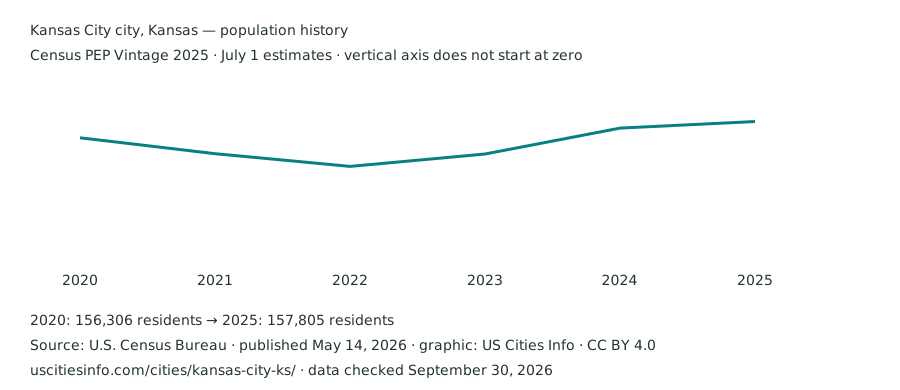
The latest official estimate is 157,805 residents on July 1, 2025. It ranks 170th by population nationally and 3rd in Kansas among this directory’s PEP places. Population changed by 610 residents between the 2024 and 2025 estimates. These are annual estimates, not census enumerations.
| Reference date | Population | Change from previous estimate |
|---|---|---|
| July 1, 2020 | 156,306 | Separate from April 2020 base |
| July 1, 2021 | 154,842 | -1,464 |
| July 1, 2022 | 153,678 | -1,164 |
| July 1, 2023 | 154,817 | +1,139 |
| July 1, 2024 | 157,195 | +2,378 |
| July 1, 2025 | 157,805 | +610 |
From the revised April 2020 base to July 2025, the change is +1,195 residents (0.8%). This is a within-vintage comparison. Boundary adjustments can affect both the estimates and their interpretation.
Download this population chart (SVG) · Official population release
Where are the boundaries?
- Entity and stable identifier
- Kansas City city, Kansas · Incorporated city · 2036000
- Counties or equivalents · 2025 boundaries
- Wyandotte County
- Metropolitan or micropolitan context · July 2023 delineations
- Kansas City, MO-KS — Metropolitan Statistical Area County associations use Census PEP county place parts. Each county is matched by FIPS code to the official CBSA list; a city can span several counties or statistical areas. A missing association can reflect an area outside a CBSA or changed county codes between vintages. City figures on this page remain place-level statistics.
- Land area
- 124.7 square miles · 2025 Gazetteer
- Water area
- 3.6 square miles · 2025 Gazetteer
- Approximate population density
- 1,265 residents per square mile of land
- Internal point
- 39.122539°, -94.741781° · Census geographic reference point
Density divides the July 2025 estimate by 2025 Gazetteer land area, so it is approximate. The internal point is a locator, not an address. Census place profile reference .
Income and poverty
| Measure / survey universe | City estimate ± MOE | State estimate ± MOE | U.S. estimate ± MOE |
|---|---|---|---|
| Median household income Households · USD/year | $62,401 ±$1,656 | $74,275 ±$475 | $80,734 ±$166 |
| Per-capita income Total population · USD/year | $29,317 ±$796 | $40,978 ±$367 | $44,673 ±$122 |
| Category | Count ± MOE | Share ± MOE (pp) |
|---|---|---|
| Below the poverty level | 24,481 ±1,786 | 16.0% ±1.2 pp |
Household income combines the incomes of everyone in a household; per-capita income divides all income by every resident. The poverty rate is 16.0% (±1.2 percentage points) under the official Census definition.
Home values, rent and tenure
| Measure / survey universe | City estimate ± MOE | State estimate ± MOE | U.S. estimate ± MOE |
|---|---|---|---|
| Median owner-occupied home value Owner-occupied housing units · USD | $167,400 ±$4,741 | $217,200 ±$1,343 | $332,700 ±$236 |
| Median gross rent Renter-occupied units paying cash rent · USD/month | $1,123 ±$23 | $1,060 ±$7 | $1,413 ±$2 |
| Category | Count ± MOE | Share ± MOE (pp) |
|---|---|---|
| Owner occupied | 34,735 ±1,001 | 60.9% ±1.7 pp |
| Renter occupied | 22,281 ±962 | 39.1% ±1.6 pp |
Owner-occupied units make up 60.9% of occupied housing. Gross rent includes estimated tenant-paid utilities and home values are owners’ own estimates; both cover 2020–2024 leases and homes rather than current listings. The median home value is 2.7 times the median household income.
See housing units, occupancy, rent burden and homeowner costs .
Monthly rent by bedroom count
| Bedrooms | Monthly gross rent | 90% margin of error | Precision |
|---|---|---|---|
| No bedroom (studio) | $802 | ±$75 | Estimate with MOE |
| 1 bedroom | $924 | ±$41 | Estimate with MOE |
| 2 bedrooms | $1,122 | ±$20 | Estimate with MOE |
| 3 bedrooms | $1,355 | ±$47 | Estimate with MOE |
| 4 bedrooms | $1,448 | ±$202 | Estimate with MOE |
| 5 or more bedrooms | $1,411 | ±$216 | Estimate with MOE |
Census table B25031 describes renter-occupied units paying cash rent within this exact place geography. Gross rent includes contract rent and estimated tenant-paid utilities. These survey medians include existing leases across 2020–2024; they are not current apartment listings. Missing categories stay unavailable, and open-ended medians remain ranges. Small bedroom categories can have large margins of error. Download source values and provenance .
Employment among residents
| Category | Count ± MOE | Share ± MOE (pp) |
|---|---|---|
| In the labor force | 77,816 ±1,312 | 66.5% ±1.1 pp |
| Not in the labor force | 39,288 ±1,509 | 33.5% ±1.3 pp |
| Category | Count ± MOE | Share ± MOE (pp) |
|---|---|---|
| Civilian employed | 72,990 ±1,344 | 94.2% ±0.8 pp |
| Civilian unemployed | 4,505 ±490 | 5.8% ±0.6 pp |
These estimates describe residents of Kansas City wherever they work; jobs at workplaces inside the city appear under jobs located in Kansas City. They are 2020–2024 averages, not a current monthly unemployment rate.
Which industries employ residents?
Education, health care and social assistance is the largest of the published broad industry groups among employed residents: 18.7% (13,685 people; ±1.2 percentage points). The estimate covers residents’ industries wherever they work, rather than employers located inside the place.
| Category | Count ± MOE | Share ± MOE (pp) |
|---|---|---|
| Agriculture, forestry, fishing, hunting and mining | 499 ±206 | 0.7% ±0.3 pp |
| Construction | 7,571 ±573 | 10.4% ±0.8 pp |
| Manufacturing | 9,176 ±840 | 12.6% ±1.1 pp |
| Wholesale trade | 2,414 ±427 | 3.3% ±0.6 pp |
| Retail trade | 8,763 ±829 | 12.0% ±1.1 pp |
| Transportation, warehousing and utilities | 6,289 ±637 | 8.6% ±0.9 pp |
| Information | 1,008 ±259 | 1.4% ±0.4 pp |
| Finance, insurance, real estate, rental and leasing | 3,451 ±433 | 4.7% ±0.6 pp |
| Professional, scientific, management, administrative and waste services | 6,668 ±605 | 9.1% ±0.8 pp |
| Education, health care and social assistance | 13,685 ±898 | 18.7% ±1.2 pp |
| Arts, entertainment, recreation, accommodation and food services | 6,338 ±603 | 8.7% ±0.8 pp |
| Other services, except public administration | 3,790 ±450 | 5.2% ±0.6 pp |
| Public administration | 3,338 ±472 | 4.6% ±0.6 pp |
Occupations among employed residents
| Category | Count ± MOE | Share ± MOE (pp) |
|---|---|---|
| Management, business, science and arts | 20,535 ±964 | 28.1% ±1.2 pp |
| Service occupations | 13,123 ±762 | 18.0% ±1.0 pp |
| Sales and office | 14,084 ±855 | 19.3% ±1.1 pp |
| Natural resources, construction and maintenance | 9,007 ±657 | 12.3% ±0.9 pp |
| Production, transportation and material moving | 16,241 ±972 | 22.3% ±1.3 pp |
| Category | Count ± MOE | Share ± MOE (pp) |
|---|---|---|
| Management occupations | 5,822 ±618 | 8.0% ±0.8 pp |
| Computer and mathematical occupations | 1,734 ±309 | 2.4% ±0.4 pp |
| Educational instruction and library occupations | 3,721 ±477 | 5.1% ±0.6 pp |
| Health practitioners and technical occupations | 3,307 ±444 | 4.5% ±0.6 pp |
| Sales and related occupations | 5,998 ±648 | 8.2% ±0.9 pp |
| Transportation occupations | 2,714 ±421 | 3.7% ±0.6 pp |
The detailed groups are subsets of the broad groups and should not be added to them.
How residents get to work
| Category | Count ± MOE | Share ± MOE (pp) |
|---|---|---|
| Drove alone | 53,170 ±1,635 | 73.9% ±1.8 pp |
| Carpooled | 9,204 ±904 | 12.8% ±1.2 pp |
| Public transportation | 850 ±282 | 1.2% ±0.4 pp |
| Taxi or ride-hailing | 444 ±317 · low precision | 0.6% ±0.4 pp · low precision |
| Motorcycle | 49 ±40 · low precision | 0.1% ±0.1 pp · low precision |
| Bicycle | 195 ±104 · low precision | 0.3% ±0.1 pp · low precision |
| Walked | 985 ±260 | 1.4% ±0.4 pp |
| Other means | 478 ±222 | 0.7% ±0.3 pp |
| Worked from home | 6,610 ±688 | 9.2% ±0.9 pp |
| Category | Count ± MOE | Share ± MOE (pp) |
|---|---|---|
| Under 15 minutes | 15,617 ±999 | 23.9% ±1.4 pp |
| 15–29 minutes | 32,433 ±1,441 | 49.6% ±1.9 pp |
| 30–44 minutes | 12,708 ±990 | 19.4% ±1.5 pp |
| 45–59 minutes | 2,577 ±460 | 3.9% ±0.7 pp |
| 60 minutes or longer | 2,040 ±416 | 3.1% ±0.6 pp |
| Category | Count ± MOE | Share ± MOE (pp) |
|---|---|---|
| No vehicle available | 4,154 ±450 | 7.3% ±0.8 pp |
Travel times cover workers who did not work from home. Vehicle availability is counted per household, not per driver.
Households and residents
Median age is 33.9 years (±0.4). The demographic profile covers age groups, race and Hispanic origin, household types, nativity, languages, education and moves, each compared with Kansas and the U.S.
How many jobs are located in Kansas City?
Employers in Kansas City reported 85,615 jobs in 2023, -0.7% compared with 2019 (86,236 jobs). That is 55.3 jobs for every 100 residents in the July 2023 population estimate. These are jobs at workplaces inside the city limits, wherever the workers live, unlike resident employment figures.
| Industry | Jobs | Share of local jobs | Kansas share |
|---|---|---|---|
| Health care and social assistance | 20,115 | 23.5% | 15.4% |
| Transportation and warehousing | 10,410 | 12.2% | 4.5% |
| Manufacturing | 10,039 | 11.7% | 12.0% |
| Retail trade | 7,115 | 8.3% | 10.2% |
| Accommodation and food services | 5,627 | 6.6% | 8.0% |
| Educational services | 5,604 | 6.5% | 9.9% |
| Administrative, support and waste management services | 5,160 | 6.0% | 5.4% |
| Wholesale trade | 4,439 | 5.2% | 4.2% |
| Construction | 4,159 | 4.9% | 5.0% |
| Public administration | 3,071 | 3.6% | 5.2% |
| Professional, scientific and technical services | 2,520 | 2.9% | 5.7% |
| Other services, except public administration | 1,700 | 2.0% | 2.7% |
| Arts, entertainment and recreation | 1,466 | 1.7% | 1.4% |
| Management of companies and enterprises | 1,355 | 1.6% | 1.7% |
| Real estate and rental and leasing | 1,003 | 1.2% | 1.1% |
| Finance and insurance | 887 | 1.0% | 4.1% |
| Utilities | 663 | 0.8% | 0.6% |
| Information | 180 | 0.2% | 1.5% |
| Mining, quarrying, and oil and gas extraction | 87 | 0.1% | 0.5% |
| Agriculture, forestry, fishing and hunting | 15 | 0.0% | 0.9% |
| Group | Jobs | Share | Kansas share |
|---|---|---|---|
| $1,250 a month or less | 13,608 | 15.9% | 20.1% |
| $1,251 to $3,333 a month | 19,903 | 23.2% | 26.9% |
| More than $3,333 a month | 52,104 | 60.9% | 53.0% |
| Age 29 or younger | 18,390 | 21.5% | 23.9% |
| Age 30 to 54 | 46,307 | 54.1% | 51.2% |
| Age 55 or older | 20,918 | 24.4% | 24.9% |
Health care and social assistance is the largest sector for jobs located in Kansas City (23.5% of local jobs, compared with 15.4% statewide). Earnings bands describe what each job pays per month, not household income, and a worker can hold more than one job.
Source: Census LEHD Origin-Destination Employment Statistics (LODES) 8.4, workplace area characteristics, all jobs, second-quarter reference date. Census blocks are summed to 2024 place boundaries. Includes private, state and local government and federal civilian jobs; excludes self-employment, military and informal work. Counts include confidentiality noise and are less precise for small places.
Nearby station climate normals
KANSAS CITY DOWNTOWN AP, MO (NOAA station USW00013988) is approximately 12.5 km from this place’s Census internal point. The table describes that station’s 1991–2020 climate normals, using NOAA’s corrected version 1.0.1. It is historical station context, rather than a forecast or an average across the city.
| Month | Average daily high (°F) | Average daily low (°F) | Precipitation (inches) |
|---|---|---|---|
| January | 39.9 | 22.2 | 1.02 |
| February | 45.1 | 26.4 | 1.53 |
| March | 56.6 | 36.2 | 2.08 |
| April | 66.8 | 46.3 | 3.89 |
| May | 76.2 | 57.2 | 5.10 |
| June | 85.8 | 67.2 | 5.33 |
| July | 90.2 | 71.9 | 4.38 |
| August | 88.6 | 69.9 | 4.68 |
| September | 80.4 | 61.0 | 3.78 |
| October | 68.2 | 48.7 | 3.24 |
| November | 54.5 | 36.3 | 1.80 |
| December | 43.9 | 26.7 | 1.30 |
Station location: 39.1208°, -94.5969°; elevation 226.2 meters. We select the nearest station within 25 km with all 12 months of high/low temperature and precipitation marked “S” (standard) by NOAA. Standard normals meet NOAA’s data-availability rules and can include estimated missing months. Distance is a straight-line great-circle calculation from the Census internal point. Coastal exposure, elevation and urban conditions can differ between the station and an address. NOAA normals and definitions · Original station CSV · Retained station data, flags and matching details .
Check a specific address before moving
City averages help compare places. A particular home’s school assignment, transit service and flood-map coverage need checks at the address.
- FEMA Flood Map Service Center — search the address, read the effective map and its date, and check any map changes. An unmapped location does not establish an absence of flood risk.
- NCES public school district directory — find district contact information, then use the district’s official address locator or enrollment office to confirm school assignment. A city name or district boundary alone does not assign a school.
- FCC National Broadband Map — check reported service at the exact location, then confirm availability and terms with the provider.
- Check the official transit operator’s route map and timetable for the address and your actual travel hours; the citywide commuting shares above do not measure service on a particular street.
Sources and data notes
Population: Census PEP Vintage 2025, published May 14, 2026. Survey measures: ACS 2020–2024 five-year estimates, published January 29, 2026, dollar figures in 2024 dollars. Geography: Census 2025 Gazetteer, with simplified 2024 state outlines for the locator. Statistical estimates and derived values use the same retained records in profiles, comparison, filters and downloads.
Climate uses NOAA 1991–2020 station normals (v1.0.1); jobs located in the city use LEHD LODES 8.4. Crime, school assignments and hazard scores are not inferred from these datasets, and missing values are never treated as zero. Inspect original sources, read calculation details, download this place’s source observations , or submit a correction.