
Diamondhead, Arkansas
Population, housing costs, incomes, jobs, commuting and climate in Diamondhead, compared with Arkansas and the U.S. using Census records and their margins of error.
Diamondhead city · Incorporated city · Census GEOID 0518880 · Arkansas directory
- Population · July 1, 2025
- 893 PEP Vintage 2025
- Change · 2024 to 2025
- -0.4% -4 residents
- Household income
- Unavailable ACS 2020–2024 · MOE unavailable
- Home value
- Unavailable ACS 2020–2024 · MOE unavailable
- Monthly gross rent
- Unavailable ACS 2020–2024 · MOE unavailable
- Median age
- Unavailable ACS 2020–2024 · MOE unavailable
Diamondhead is an incorporated city in Garland County, Arkansas, part of the Hot Springs, AR metropolitan area. With 893 residents on July 1, 2025, it ranks 194th in Arkansas and 10,777th nationally among Census places. Its population fell by 4 (0.4%) in the year to July 2025; since April 2020 it has declined 2.3%. A compatible ACS place record is unavailable; housing and resident survey estimates are not substituted from a county or metro area.
What stands out in Diamondhead?
None of Diamondhead’s reliable measures falls far from the middle of Arkansas places, or the survey sample is too small for a confident comparison. The table below shows every available measure with its precision so you can judge the differences yourself.
How Diamondhead compares with Arkansas and the U.S.
| Measure | Diamondhead | Arkansas | U.S. | Position in Arkansas |
|---|---|---|---|---|
| Population change since April 2020 PEP Vintage 2025 | -2.3% | — | — | lower than 61% of 449 Arkansas places |
| Residents per square mile of land PEP 2025 / Gazetteer 2025 | 379 | — | — | lower than 51% of 500 Arkansas places |
Positions compare Diamondhead with Arkansas places in this directory whose estimate has a coefficient of variation of 30% or less (survey measures) or a published PEP value. The marker runs from the lowest value (left) to the highest (right); it is a description, not a score or a recommendation. With 893 residents, Diamondhead has a small ACS sample; prefer the population and geography records for precise comparisons.
How many people live in Diamondhead?
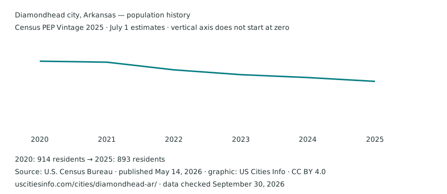
The latest official estimate is 893 residents on July 1, 2025. It ranks 10,777th by population nationally and 194th in Arkansas among this directory’s PEP places. Population changed by 4 residents between the 2024 and 2025 estimates. These are annual estimates, not census enumerations.
| Reference date | Population | Change from previous estimate |
|---|---|---|
| July 1, 2020 | 914 | Separate from April 2020 base |
| July 1, 2021 | 913 | -1 |
| July 1, 2022 | 905 | -8 |
| July 1, 2023 | 900 | -5 |
| July 1, 2024 | 897 | -3 |
| July 1, 2025 | 893 | -4 |
From the revised April 2020 base to July 2025, the change is −21 residents (-2.3%). This is a within-vintage comparison. Boundary adjustments can affect both the estimates and their interpretation.
Download this population chart (SVG) · Official population release
Where are the boundaries?
- Entity and stable identifier
- Diamondhead city, Arkansas · Incorporated city · 0518880
- Counties or equivalents · 2025 boundaries
- Garland County
- Metropolitan or micropolitan context · July 2023 delineations
- Hot Springs, AR — Metropolitan Statistical Area County associations use Census PEP county place parts. Each county is matched by FIPS code to the official CBSA list; a city can span several counties or statistical areas. A missing association can reflect an area outside a CBSA or changed county codes between vintages. City figures on this page remain place-level statistics.
- Land area
- 2.4 square miles · 2025 Gazetteer
- Water area
- 0.4 square miles · 2025 Gazetteer
- Approximate population density
- 379 residents per square mile of land
- Internal point
- 34.439572°, -92.957986° · Census geographic reference point
Density divides the July 2025 estimate by 2025 Gazetteer land area, so it is approximate. The internal point is a locator, not an address. Census place profile reference .
Survey coverage for Diamondhead
No exact GEOID match exists in the retained ACS 2020–2024 place tables. This can arise from changed entity definitions or boundaries; a same-name county subdivision is not substituted. The population history, official place identifier and Gazetteer geography above remain available.
How many jobs are located in Diamondhead?
This place code is not in the LODES 2024 geography crosswalk, which can happen after a recent incorporation or code change. Jobs are not borrowed from a county or similarly named place.
Nearby station climate normals
HOT SPRINGS ASOS, AR (NOAA station USW00003962) is approximately 19.1 km from this place’s Census internal point. The table describes that station’s 1991–2020 climate normals, using NOAA’s corrected version 1.0.1. It is historical station context, rather than a forecast or an average across the city.
| Month | Average daily high (°F) | Average daily low (°F) | Precipitation (inches) |
|---|---|---|---|
| January | 52.6 | 32.7 | 3.39 |
| February | 57.0 | 35.9 | 4.10 |
| March | 65.7 | 43.3 | 4.90 |
| April | 74.3 | 51.1 | 5.09 |
| May | 81.4 | 60.6 | 5.89 |
| June | 89.3 | 68.9 | 4.54 |
| July | 93.3 | 72.2 | 3.99 |
| August | 93.2 | 71.1 | 3.33 |
| September | 86.3 | 64.0 | 3.62 |
| October | 75.3 | 52.3 | 4.89 |
| November | 63.1 | 42.0 | 4.49 |
| December | 54.4 | 35.0 | 4.64 |
Station location: 34.29°, -93.06°; elevation 163.1 meters. We select the nearest station within 25 km with all 12 months of high/low temperature and precipitation marked “S” (standard) by NOAA. Standard normals meet NOAA’s data-availability rules and can include estimated missing months. Distance is a straight-line great-circle calculation from the Census internal point. Coastal exposure, elevation and urban conditions can differ between the station and an address. NOAA normals and definitions · Original station CSV · Retained station data, flags and matching details .
Check a specific address before moving
City averages help compare places. A particular home’s school assignment, transit service and flood-map coverage need checks at the address.
- FEMA Flood Map Service Center — search the address, read the effective map and its date, and check any map changes. An unmapped location does not establish an absence of flood risk.
- NCES public school district directory — find district contact information, then use the district’s official address locator or enrollment office to confirm school assignment. A city name or district boundary alone does not assign a school.
- FCC National Broadband Map — check reported service at the exact location, then confirm availability and terms with the provider.
- Check the official transit operator’s route map and timetable for the address and your actual travel hours; the citywide commuting shares above do not measure service on a particular street.
Sources and data notes
Population: Census PEP Vintage 2025, published May 14, 2026. Survey measures: ACS 2020–2024 five-year estimates, published January 29, 2026, dollar figures in 2024 dollars. Geography: Census 2025 Gazetteer, with simplified 2024 state outlines for the locator. Statistical estimates and derived values use the same retained records in profiles, comparison, filters and downloads.
Climate uses NOAA 1991–2020 station normals (v1.0.1); jobs located in the city use LEHD LODES 8.4. Crime, school assignments and hazard scores are not inferred from these datasets, and missing values are never treated as zero. Inspect original sources, read calculation details, download this place’s source observations , or submit a correction.